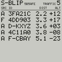
Where to look, and who is there.
The page a skyBlip Go is left on: where to look, who is there, and what the alarm means when it speaks.
What you see in flight
Traffic drawn the way you see it.
You are in the middle, nose up, and the picture never turns: the sky turns around you. Traffic drawn to the upper right is traffic to look for off the right of the nose, with nothing to convert. Nothing at all is written across the top of the glass, because that is the half you are flying into.
Each aircraft is a shape, and the shape already says where to raise your eyes: point up, it is above you; point down, below; a diamond, at your level. A caret joins it if it is climbing or sinking, and the line out of it leads where it will be in a minute.
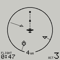
- Heading up, never north up
- Ring of 1, 2, 4 or 8 NM
- The shape says above, level or below
- A minute of track ahead of each target
- The count of every aircraft heard
- Flight time, for the logbook
Every aircraft, however far.
To scale, the picture ends at the glass: on the 4 NM ring an aircraft past about six miles is gone. With PLOT on ALL, the first choice on the settings menu and the one a device ships on, nothing heard with a position is left off. The ring shrinks to leave a band around it, and an aircraft past the ring stands on that band, on its bearing, wearing the shape it would wear inside.
Its distance is not drawn, its minute of track is: to scale, from where the aircraft really is, and only the part inside the ring. An aircraft closing fast from six miles is a mark on the band and a line already inside the ring, ending where it will be in a minute.
Aircraft close together on the band become one mark with a count beside it, and the mark shown is the one that matters first: an alarm, then the closest to your altitude. The count never covers another aircraft, and a mark behind you steps aside from the range label rather than hide under it.
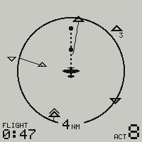
- ALL, the default: every aircraft with a position
- TO SCALE: the picture drawn to the ring
- On the band: the bearing, the shape, the alarm
- A minute of track, where it enters the ring
- Neighbours on the band share one mark and a count
- The corner counts every aircraft heard
The screens page shows the same skies both ways, one press of the button apart.
One alarm, and it says where to look.
An aircraft inside 3 km and 300 m of you has its symbol filled in, and a quarter of the screen centred on it goes black, once a second. You have nothing to read: a corner of the glass flashing is caught out of the corner of your eye, and that is the whole instruction, turn your head that way. Whatever page you are on, the radar takes over.
The black sector catches the eye, the symbol gives you the angle. Traffic 38° off the nose is not rounded up to “ahead and right”: the sector leans on its 38°, and you look there rather than through a quarter of the sky.
There is nothing above it, and there never will be. Climbing or descending has to be coordinated with the other aircraft, and this device has no link to do it over. The loudest thing it can say is look.
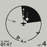
- 3 km around you, 300 m above and below
- A quarter of the screen, centred on the traffic
- One flash a second
- The buzzer, the vibration and the lamp with it
- One touch of the pad silences it
- A caution, never an instruction
Five shapes, and you read them without learning them.
Point up is traffic above you; point down is traffic below; the diamond is someone inside your 60 m. A full-size symbol sits within the 300 m the alarm cares about; a reduced one is further away vertically, and it stays on the picture without ever asking for it. The caret joins from 2.5 m/s of climb or descent, on the side the traffic is going.
Filled black belongs to the alarm. While no symbol is filled, nothing is urgent: it is the one contrast the screen keeps in reserve.
| Plain | Alarm | |||||
|---|---|---|---|---|---|---|
| climbing | steady | sinking | climbing | steady | sinking | |
| Point up above you, to 300 m |  |
 |
 |
 |
 |
 |
| Diamond within 60 m of your level |  |
 |
 |
 |
 |
 |
| Point down below you, to 300 m |  |
 |
 |
 |
 |
 |
| Point up, reduced above you, beyond 300 m |  |
 |
 |
outside the alarm’s altitude window | ||
| Point down, reduced below you, beyond 300 m |  |
 |
 |
outside the alarm’s altitude window | ||
Who is out there, nearest first.
The radar says where to look, this page says who that is. One row per aircraft the device can place: its callsign if it broadcasts one and its address otherwise, the ground distance between you, and how far above or below you it is. On the top line, your own callsign with the address you transmit under beside it, and the count of everything heard.
The letter at the head of the row says where the report came from. A for a direct ADS-L frame, F for FLARM-compatible traffic, U for an aircraft relayed by a ground station.